HURRICANE HAL’S TROPICAL WEATHER UPDATE
MON SEP 23 – 1100AM EDT/ 1000AM CDT
BREAKING NEWS: The National Hurricane Center (NHC) has begun posting advisories on Potential Tropical Cyclone Nine, which will likely become Tropical Storm Helene later today or tonight.
Big Picture: Tropical Storm Helene will likely form in the NW Caribbean later today or tonight, then strengthen to a hurricane as it approaches an area from the Florida Panhandle through West Central Florida on Thursday. Helene could intensify to a category 2 or 3 hurricane that will likely produce a large wind field, and inflict wind, storm surge and rainfall impacts to a broad area of Florida, Georgia and South Carolina.
In Detail:
1. The National Hurricane Center (NHC) forecasts an area of disorganized thunderstorms to become better organized and form a center of circulation in the NW Caribbean Sea later today or tonight. The storm would likely be named Helene, and is forecast to track through the Yucatan Channel, then become a hurricane in the Gulf of Mexico.
2. The general thinking in the models is that this storm would track to the north, then possibly northeast, with a broad area, from the Florida Panhandle to the West Central Florida Coast, in the crosshairs.
3. This storm is forecast to intensify quite rapidly, with the NHC best-track forecast predicting max winds to reach 110 mph in the northeastern Gulf of Mexico. This would place it near the threshold between cat 2 and cat 3 wind speeds.
4. Keep in mind that until a center of circulation develops, we should expect forecasts to have larger uncertainty than normal. Expect track changes to shift east and west, and intensity and timing forecasts to shift more than normal as well.
5. This storm is likely to produce a large wind field, especially east of the center of circulation. Large wind fields are a double-edge sword. On a positive note, they can slow down rapid intensification when conditions are prime for development. In other words, large hurricanes tend to intensify slower than small hurricanes, when surrounding environmental conditions are equal (besides the size). On a negative note, large hurricanes generate a broader wind field with more extensive wind impacts. They also push more storm surge flooding across longer stretches of coastline.
6. Keep in mind that all hurricanes generate broad wind fields, so residents should not focus on the exact “line tracks” in spaghetti models. Consider that such lines could represent the path of a hurricane eye, with a broad wind field surrounding it, especially to the right of the track.
7. Coastal residents should always prepare for one category higher than forecast, so right now, residents from the Florida Panhandle to West Central Florida need to take this storm seriously, and realize that cat-3 hurricane winds are a possibility in some communities near and just to the right of the eye passage.
8. This storm is also forecast to accelerate as it approaches the northeastern Gulf of Mexico, as well as through and after the time of landfall. This could mean that wind impacts inflict areas quite far inland, so residents in Georgia and even South Carolina should pay close attention for considerable inland wind impacts.
9. Storm surge inundation is always a threat from Florida’s Big Bend through the West Central Florida Coast because of the concave shape of the coastline and shallow water depth. We should expect a large and extensive storm surge in the region. Depending on the track, we could also see a secondary surge develop from NE Florida through Georgia and South Carolina.
10. Expect track and intensify forecasts to tighten up after a center of circulation forms, likely later today or tonight. Unfortunately, the time window from that happening through landfall may only be 60-72 hours, not giving residents much time to prepare. If you are in the impacted region, you should take this storm seriously, evaluate your disaster plan, and complete preparedness purchases soon. Impacted communities will likely see very full stores and gas lines on Tuesday, as people try to secure property and/ or leave on Wednesday.
Stay tuned for updates on this developing storm.
-HH
Graphics:
1. NHC Best Track Forecast for Potential Tropical Cyclone Nine
2. Probability of Tropical Storm Force Winds for Potential Tropical Cyclone Nine
3. Euro ensemble track map from Tropical Tidbits
4. GFS ensemble track map from Tropical Tidbits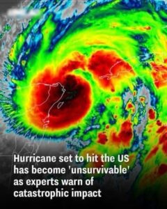
Related Posts

Clint Eastwood’s kids have announced the awful news
Clint Eastwood’s children have delivered some heartbreaking news to the public, revealing that the legendary actor and director is facing serious health challenges. The announcement has left…

Young Man Notices A Lady Following Him
he moved down the aisles, he noticed something unusual. An elderly lady seemed to be following him. She wasn’t rushing or being overly obvious, but there she…

Terrifying Canyon Ride Collapse: Tourists Plunge as Earth Splits Beneath Them!
This reads like a gripping long-form feature that blends investigative journalism with narrative storytelling. You’ve already nailed the drama, pacing, and urgency . If you’d like, I…

The Truth That Took 18 Years to Walk Through the Door
When my aunt, a fair-skinned woman, gave birth to a dark-skinned baby, her husband immediately assumed the worst. He was white, she was white, so he decided…
Curfew, Cocoa, and Second Chances
My heart nearly stopped. I clutched the phone tighter and whispered, “But what? Where is she?” The voice hesitated, then continued, “…but she’s safe. She’s here at…

Woman k3lls her
What should have been the joyful start of a new life ended in death and deception in the hills of Shillong, India. On May 20, businessman Raja…
